Walk • Trek • Travel
A photographic record and journal of our walking, trekking and travelling adventures.
Egypt Bay from High Halstow Circular
Saturday 23 March 2019
Egypt Bay. Sounds exotic, distant, possibly even fictitious. A
make-believe location in an imaginary land far, far away.
When I first read about this mysterious place, I was not reading a
fantasy novel set in some far-flung corner of make-believe with
swashbuckling pirates and smugglers. Nor was I reading some Dickensian
style period piece set in the 19th century.
If I am honest, the unremarkable if not slightly boring truth of the
matter is that I was reading an article about wild camping. Or, to be
precise, I was reading the comments that had been left by other readers
of the article on wild camping.
What is remarkable, however, is that Egypt Bay is not to be found by
looking at a map of the Middle East or by sailing around the Caribbean
under the Jolly Roger but, instead, by following the River Thames, a
river that I can see from my window as I write these words, upstream
from Gravesend for just nine miles.
What is, perhaps, even more remarkable, is that you could have easily
have read about Egypt Bay in a Dickensian classic or a story about
smuggling and never have known where to find it. But I will come to that
a little later on.
The River Thames is synonymous with the City of London and the
colourful history that is associated with it. But follow the river away
from the capital in either direction and you will still find it to be a
surprisingly rich source of history and so it is with Gravesend and the
surrounding area.
Many people will be aware of the connection to Pocahontas who died at
Gravesend in 1617 aged 21 and was buried in St George’s Church but a
lesser known fact is that, in 1381, a combined French and Spanish force
sailed up river and attacked Gravesend burning the town to the ground
and sailing off with the surviving inhabitants to be sold as slaves.
Needless to say, in the centuries that followed, the area was seen to
be vital to the defence of the capital and in protecting the vital
shipping route that capital relied upon. All along this section of the
river, you will find evidence of fortifications, gun towers and
batteries along with ordnance factories, bunkers and top-secret training
grounds.
But, while I was researching the origins of the name ‘Egypt Bay’ it
was the sad events of September 27th, 1946 that caught my attention.
Captain Geoffrey de Havilland Jnr, son of Geoffrey de Havilland Snr
the founder and owner of the de Havilland Aircraft Company Ltd was
killed while conducting test flights over the Thames estuary in
preparation for an attempt at the world air speed record. Captain de
Havilland was the Chief Test Pilot at the company and had been
conducting high-speed tests in the experimental de Havilland DH 108
“Swallow” TG306 aircraft when it suffered catastrophic structural
failure in a dive from 10,000 ft at Mach 0.9 and lost both wings.
The remains of the Aircraft were found in the mud at Egypt Bay the
following morning. Geoffrey De Havilland’s body was washed ashore at
Whitstable on 7th October 1946.
I had already decided to walk out to Egypt Bay before I had read
about Geoffrey De Havilland and the TG306 accident. My plan was to park
at High Halstow and then walk the three miles to Egypt Bay across the
marshes.
If you look at the map below, the villages of Cliffe, Cooling, High
Halstow and St Mary Hoo are all several miles from the modern-day
shoreline of the Thames this is because, before the area was
significantly drained it was marshland and a breeding ground for
mosquitos. Even today, looking at an OS map, it looks like a very wet
area. So wet that the nearby Cliffe Marshes doubled as the paddy fields
of Vietnam in Stanley Kubrick’s 1987 Vietnam war film ‘Full Metal
Jacket’.
On the Hoo Peninsula, life expectancy for adults was just thirty
years. Poverty and malnutrition were widespread in the 18th century and
in the marshlands on the peninsula, many died from malaria known locally
as marsh fever and this remained the case until the cause of malaria was
discovered in1890. By 1895 much of the marshland had been drained and
the number of deaths decreased dramatically.
Even before I reached the last building, a small farm at Swigshole, I
felt like I was walking in a remote and desolate land. High Halstow is
set on a low ridge that drops you slowly on to a massive, flat, empty
landscape crisscrossed with ditches and fleets.
It was a Saturday, about midday and in any direction I looked, I
could see no one. I was completely alone. I remained alone until I
reached the small hamlet of St Mary Hoo.
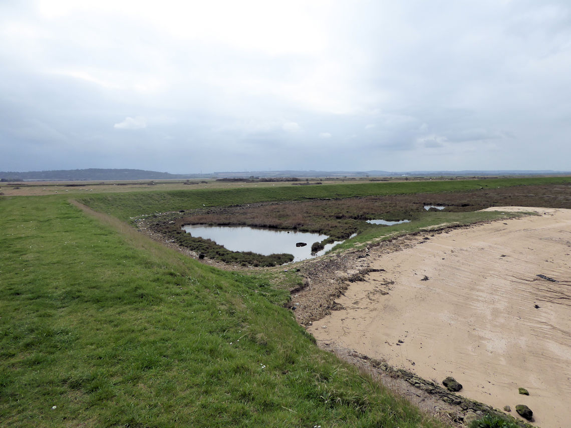
There is a small beach at Egypt Bay where I sat for a while looking
out over the Thames to Canvey Island and watching the ships sail by. To
the west, in the distance, I could see the large cranes of the London
Gateway Port. Standing in a row with an almost animal-like
appearance.
There was nothing that I could see that indicated that a tragic
accident had occurred here. No memorial stone or plaque. No information
board. Nothing at all in fact.
Nor could I see any evidence of the Prison Hulks said to have been
anchored here in the 18th and 19th Centuries. Google ‘Charles Dickens’
or ‘Great Expectations’ along with “Egypt Bay” and you will find
numerous mater of fact references telling you that Egypt Bay is the
location where some of these Prison Hulks were moored. I almost expected
to bump into Abel Magwitch himself while I was there. However, as far as
I can tell, the Prison Hulks were moored at Lower Upnor, some six miles
south of Egypt Bay, on the River Medway.
Dickens, who lived in Chatham as a young boy, knew the area well and
owned Gads Hill Place, Higham which he used as a country retreat until
his death in 1870. I suspect that having the Prison Hulks moored at
Eygpt Bay suited his purposes better and used artistic license to
relocate them.
St James Church in Cooling is largely accepted as being the
churchyard in the opening scene of Great Expectation but some believe
that it was really St Margaret’s in High Halstow while others believe it
was the churchyard in Higham itself. Cooling and High Halstow are much
closer to Egypt Bay which is actually located within the parish of High
Halstow but no one can be completely sure because Dickens never revealed
the location. Perhaps he drew inspiration from all of them and applied
some more artistic license.
So, what about smuggling? On my OS map, there was a lonely building
one kilometre south of Egypt Bay for which there seems to be no public
right of way, road or path leading to it. This is Shade House and is
supposedly a derelict Shepards House that was used by the notorious
North Kent Gang who would land their contraband at Egypt Bay. The house
was designed in such a way that all of its windows face inland which was
to allow the occupants to see anyone who might be approaching.
So what was the origin of the name ‘Egypt Bay’? In truth, no one
seems to know but it has been suggested that it may be linked to
Phoenician coins found on the Hoo Peninsula which is seen as proof that
the area had trading links with the Phoenicians who originated in the
Levant which, at the time, bordered Egypt. Perhaps that it simply more
artistic license.


The Route
Distance : 7.5 Miles
I parked at the car park in RSBP Car Park in High Halstow and walked
a circular route taking in Egypt Bay, St Mary’s Bay and St Mary Hoo.
Click HERE for
a GPX file of the route.
Are you tired of being stuck in the office? Bored of being chained to a desk? Counting down the days until retirement?
Me too!!
CATEGORIES
FOLLOW US


RECENT POSTS
-
 Tuesday 01 February 2022
 -
 Monday 31 January 2022
 -
 Sunday 30 January 2022
 -
 Saturday 29 January 2022
 -
 Friday 28 January 2022
 -
 Thursday 27 January 2022
 -
 Wednesday 26 January 2022
 -
 Tuesday 25 January 2022
 -
 Monday 24 January 2022
 -
 Sunday 23 January 2022
 -
 Saturday 22 January 2022
 -
 Friday 21 January 2022
 -
 Thursday 20 January 2022
 -
 Sunday 02 January 2022
 -
 Saturday 01 January 2022
 -
 Wednesday 27 October 2021
 -
 Tuesday 26 October 2021
 -
 Sunday 02 May 2021
 -
 Sunday 04 October 2020
 -
 Saturday 03 October 2020